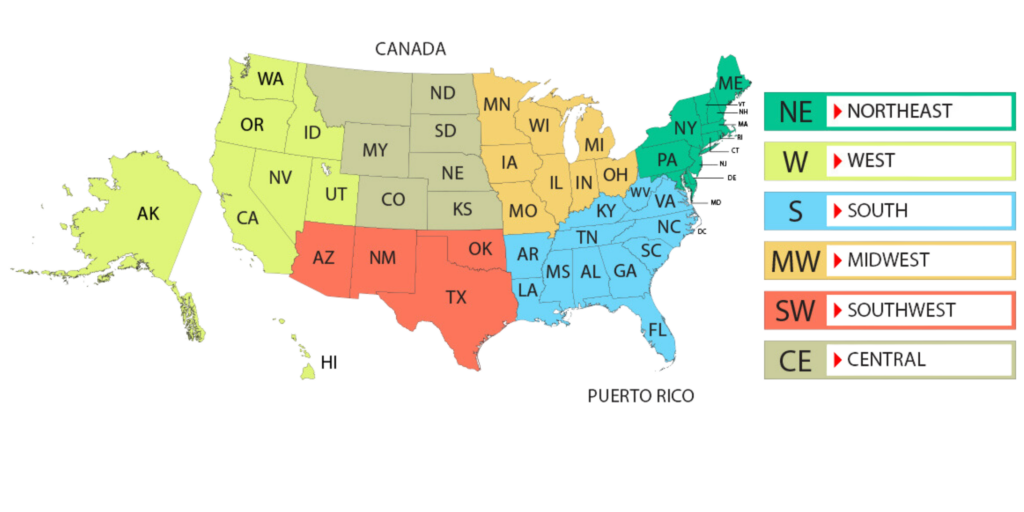
Today, we are excited to share a brand-new resource that will enrich your understanding of U.S. state abbreviations—a comprehensive, color-coded map of the United States. This map is not just visually appealing but also highly informative. It divides the U.S. into six key regions: North East, West, South, Midwest, South West, and Central. Each of these regions is represented by a unique color to facilitate easy identification and learning.
Before we dive into the details of how to read and use this map effectively, we want to clarify its purpose. We designed this map as an educational tool and as a quick reference guide for professionals, educators, students, and anyone who finds themselves needing to understand the geographical distribution of U.S. state abbreviations. The best part? You are free to copy and paste this map for your needs, as long as you provide appropriate attribution by linking back to our site.
The Color Coding Scheme
The map employs a thoughtful color scheme to distinguish between the six primary regions of the U.S. Here’s how the color coding works:
- North East: Represented in Green
- West: Displayed in Lemon
- South: Shown in Blue
- Midwest: Portrayed in Mustard Yellow
- South West: Illustrated in Dark Orange
- Central: Depicted in Army Green
This approach allows for an at-a-glance understanding of the various regions, making it easier to grasp the layout of state abbreviations across the country.
States and Their Abbreviations by Region
For your convenience and to enhance your experience with our map, here’s a definitive list of states and their abbreviations, divided by their corresponding regions as illustrated on our color-coded map.
North East in Green:
- Connecticut (CT)
- Maine (ME)
- Massachusetts (MA)
- New Hampshire (NH)
- New Jersey (NJ)
- New York (NY)
- Pennsylvania (PA)
- Rhode Island (RI)
- Vermont (VT)
- Maryland (MD)
- Delaware (DE)
South in Blue:
- Alabama (AL)
- Arkansas (AR)
- Florida (FL)
- Georgia (GA)
- Kentucky (KY)
- Louisiana (LA)
- Washington DC (DC)
- Mississippi (MS)
- North Carolina (NC)
- South Carolina (SC)
- Tennessee (TN)
- Virginia (VA)
- West Virginia (WV)
Midwest in Mustard Yellow:
- Illinois (IL)
- Indiana (IN)
- Iowa (IA)
- Michigan (MI)
- Minnesota (MN)
- Missouri (MO)
- Ohio (OH)
- Wisconsin (WI)
South West in Dark Orange:
- Arizona (AZ)
- Texas (TX)
- New Mexico (NM)
- Oklahoma (OK)
Central in Army Green:
- Montana (MT)
- Wyoming (WY)
- Colorado (CO)
- Kansas (KS)
- Nebraska (NE)
- North Dakota (ND)
- South Dakota (SD)
West in Lemon:
- Alaska (AK)
- California (CA)
- Hawaii (HI)
- Oregon (OR)
- Washington (WA)
- Nevada (NV)
- Idaho (ID)
- Utah (UT)
How to Read the Map
Reading the map is straightforward. Each state is labeled with its respective abbreviation. Moreover, the color-coding facilitates a quick understanding of which region each state belongs to. For example, if you see the abbreviation ‘CA,’ you can easily identify it as California, and its lemon color will immediately indicate that it belongs to the West region.
Tips for Reading the Map
Legend Understanding:
The color legend, located at the side of the map is one of the most important elements to understand when you’re first acquainted with the map. It serves as your guide to deciphering the different regions as represented by unique color codes. Since each color corresponds to a specific region—like North East in Green or South in Blue—the legend essentially works as a decoding tool.
Without a good understanding of the legend, you might find the map to be just a colorful representation of the United States. But once you comprehend the colors, the map suddenly becomes a rich, informative tool that allows you to instantly recognize which states fall under which regions. Make it a point to study the legend first before you proceed to analyze the map.
State Recognition:
If you’re new to U.S. state abbreviations, you could initially find the map to be overwhelming. In such a scenario, having a list of abbreviations and their full-form names handy can be a lifesaver. You could either print out a list or have one open on a different tab or device for quick reference.
By cross-referencing this list with the map, you’ll begin to memorize the abbreviations faster. The map itself serves as a visually engaging tool to test your memory as you go along. The more you engage with it, the quicker you’ll become accustomed to the abbreviations, turning the map into an even more valuable resource.
Contextual Clues:
Geographical context can be a powerful tool for learning and recalling state abbreviations. For example, if you know that ‘TX’ stands for Texas, you can likely guess that the abbreviation ‘OK’ next to it stands for Oklahoma. Similarly, ‘NY’ for New York will naturally be near ‘NJ’ for New Jersey.
It’s not just about geography; cultural, historical, and even meteorological aspects can give you hints. States with similar climates, industries, or histories often lie close to each other. By combining your understanding of the United States’ geography with the abbreviations, you can turn the map into a multi-layered learning experience.
Zoom In/Out:
Many regions in the United States are densely packed with states, such as the North East. In these areas, the state abbreviations on the map may appear small and challenging to read, especially if you’re viewing the map on a smaller screen. That’s where the zoom feature comes into play.
Most digital maps come with a zoom-in/zoom-out feature. Utilize this to closely examine regions of interest. By zooming in, you not only get a clearer view of the abbreviations but can also pay attention to the borders and how states are geographically aligned. This is especially useful for studying smaller states or for seeing how states in one region are interconnected.
How to Use the Map
This map is versatile in its utility and can serve various purposes:
- Educational Use: Teachers can incorporate this map into their curriculum to help students learn about state abbreviations and U.S. geography.
- Professional Use: For those in logistics, travel, or any industry requiring geographical knowledge, this map serves as a quick reference tool.
- General Knowledge: For trivia nights, quizzes, or general knowledge enhancement, this map is a handy resource.
- Web Development: Those involved in SEO or website development can use this map as a reference for targeting regional keywords or audiences.
- Travel Planning: If you’re planning a trip and want to know which states fall under a specific region, our map can guide you.
Attribution Guidelines
You are welcome to use this map for any purpose—blogs, articles, academic papers, or business reports—as long as you attribute it correctly. To do this:
- Copying the Map: Simply right-click on the map to copy it, and then paste it into your desired location.
- Attribution: Please include a link back to our website underneath the map, with text along the lines of: “Map Od The U.S. courtesy of AllStateAbbreviations”
Additional Information
Updates and Accuracy
We make every effort to keep this map updated. However, if you notice any inconsistencies, please feel free to contact us.
Customization Requests
If you require a customized version of this map for specific needs, please get in touch for possible collaboration.
Feedback and Suggestions
We are open to feedback and suggestions for improving the map. If you have any ideas, please share them with us.
Interesting Facts and General Information About the U.S. Map
While our map primarily focuses on the abbreviations and regions of the United States, it’s part of a long tradition of cartography that tells the story of this vast nation. Here are some additional facts and generic pieces of information about the U.S. map that might pique your curiosity:
Geographic Diversity:
The United States covers a vast geographical area, stretching from the Atlantic Ocean in the east to the Pacific Ocean in the west. It’s interesting to note that Alaska is the westernmost, easternmost, and northernmost state in the U.S. because the Aleutian Islands extend into the Eastern Hemisphere. Hawaii, on the other hand, is the southernmost state. This wide geographical span is an important aspect to consider when interpreting any U.S. map.
Changing Boundaries:
The boundaries of the U.S. have changed significantly over time. Originally confined to the 13 Colonies along the Atlantic coast, the nation expanded westward through acquisitions like the Louisiana Purchase, wars, and treaties. These shifting boundaries are often subjects of historical maps but provide context for any current representation of the U.S.
Time Zones:
The United States spans six different time zones from Hawaii to the Eastern Standard Time zone. When you look at the U.S. map, consider how time changes from one end to the other, affecting everything from business to television programming schedules.
Natural Features:
Many U.S. maps also depict natural features like rivers, mountain ranges, and lakes. The Mississippi and Missouri Rivers are among the longest river systems in the world, and the Rocky Mountains, Sierra Nevada, and Cascades are significant mountain ranges in the western part of the country. These natural features have shaped state boundaries, human settlement patterns, and are significant to understand the overall geography.
Capital Cities:
While the focus of our map is on state abbreviations and regions, most U.S. maps will indicate the state capitals. Interestingly, not all capital cities are the most populated cities in their states. For example, New York City is far larger than Albany, but Albany is the state capital.
Interstate Highways:
Initiated in the 1950s, the U.S. Interstate system is often included in modern road maps. These highways are part of a network that makes up one of the world’s largest national transportation systems, covering over 48,000 miles.
Cultural Regions:
Beyond the color-coded regions on our map, the U.S. can also be divided into various cultural regions like the Deep South, the Midwest, and New England. Each of these has unique traditions, accents, and histories, adding another layer of depth to how one can understand the United States.
Native American Reservations:
While not the focus of our map, it’s worth noting that Native American reservations are also an important part of the U.S. landscape, with their own unique jurisdictions and governance.
Incorporating this general knowledge about the U.S. map can deepen your understanding of this complex and fascinating country, whether you are using our map for educational, professional, or personal reasons. Happy exploring!
Conclusion
This color-coded U.S. state abbreviations map is designed to be more than just a static image; it is a dynamic tool for learning, reference, and even for business applications. We hope you find this map as useful as we do, and we encourage you to share it while adhering to the attribution guidelines.
Thank you for taking the time to learn about this valuable resource. We’re confident that it will serve you well in your endeavors, whatever they may be.
Happy mapping!